

What is a LiDAR Scanner? The Ultimate Guide for Professionals
Tired of watching your project timelines and budgets get crushed by slow, outdated surveying methods? If you're demanding more accurate data and faster results than standard cameras can provide, it’s time to elevate your capabilities. Enter the absolute game-changer for enterprise drones: the lidar scanner. But let's be real-the buzz around complex terms like 'point cloud' and 'photogrammetry' can be confusing, leaving you wondering if this high-tech tool is truly worth the investment. That’s why we’re here to cut through the noise!
Get ready to unlock the true power of 3D mapping! In this ultimate guide, we’ll break down exactly how this revolutionary technology works, showcase jaw-dropping real-world examples, and give you the expert insights you need to decide if LiDAR is the right move for your industry. By the end, you'll not only understand what a LiDAR scanner is, you'll have the confidence to know precisely what to look for when adding this professional power to your drone fleet. Let's get started!
What is LiDAR and How Does It Actually Work?
Ever wondered how self-driving cars see the world or how incredibly detailed 3D maps are made? The secret is LiDAR! Think of it like radar, but instead of radio waves, it uses powerful, eye-safe laser light. The name itself is a dead giveaway: LiDAR stands for Light Detection and Ranging. At its core, the technology behind what is LiDAR is all about using rapid light pulses to measure distance with mind-blowing precision.
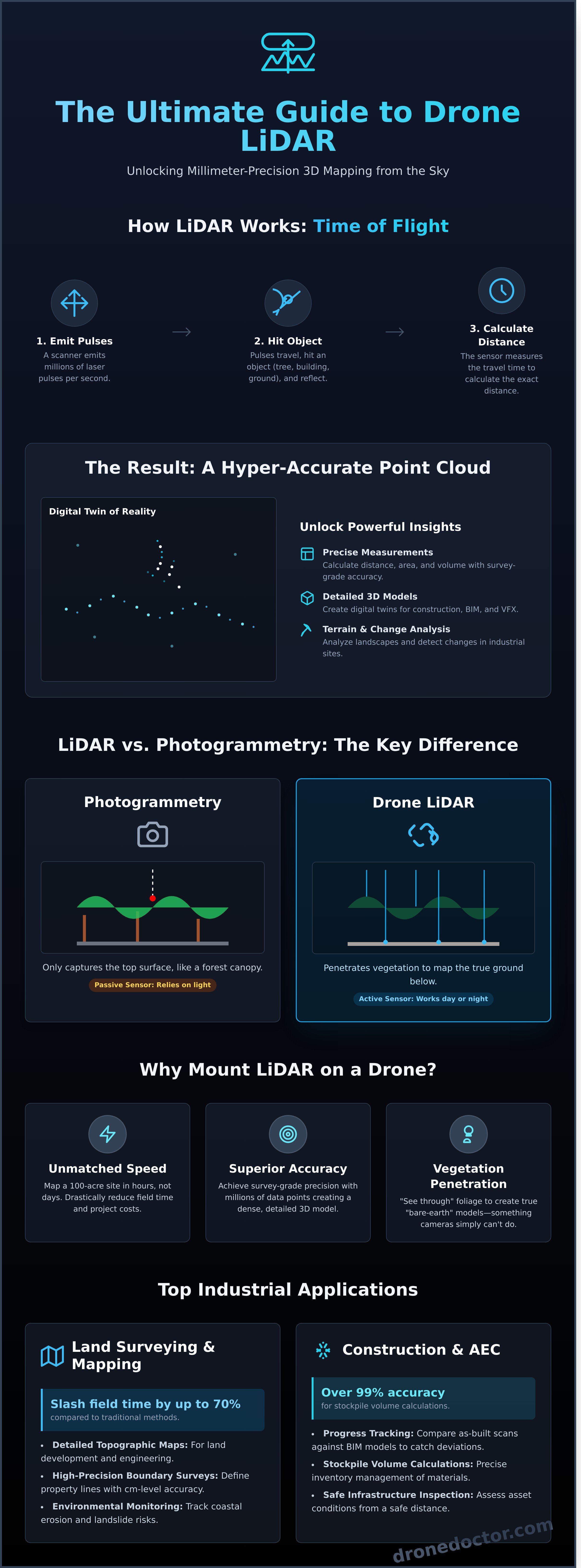
The process is brilliantly simple. A lidar scanner emits millions of laser pulses per second. These pulses travel outwards, hit an object-like a building, a tree, or the ground-and bounce back to the sensor. The system then measures the exact time it took for each pulse to make this round trip. This is called 'Time of Flight' (ToF), and by knowing the constant speed of light, the scanner can instantly calculate the precise distance to that object.
LiDAR Explained in Simple Terms
Imagine you’re in a dark room and want to know how far away a wall is. You could throw a tennis ball at it and time how long it takes to hit the wall and for you to hear the sound. A LiDAR sensor does the same thing, but with millions of laser beams per second! It rapidly sweeps the environment, sending out pulses in every direction. Each returning pulse gives it a single measurement point with a precise X, Y, and Z coordinate, building a 3D map instead of a flat 2D image.
The Key Output: Understanding the Point Cloud
So, what do you get from these millions of measurements? The raw output is a point cloud-a massive collection of individual points plotted in 3D space. This isn't just a picture; it's a geometrically perfect, incredibly accurate digital twin of the scanned area. This data, often saved in formats like .LAS or .LAZ, unlocks the power to:
- Take precise measurements of distance, area, and volume.
- Create highly detailed 3D models for construction, surveying, and VFX.
- Analyze terrain for agriculture or environmental monitoring.
- Detect changes and clashes in complex industrial environments.
Beyond these industrial applications, the ability to create a digital twin of reality also opens doors for creative and educational uses. The same principles of 3D mapping can be applied to build engaging virtual environments. For example, Immersive Experiences specializes in creating shared virtual reality spaces within large-scale domes for events, demonstrating the broader potential of crafting engaging 3D worlds.
Why Mount a LiDAR Scanner on a Drone? The Key Advantages
Imagine combining the go-anywhere mobility of a professional drone with the pinpoint precision of a laser scanner. That’s the game-changing power you unlock when you mount a lidar scanner on a drone. This dynamic duo is revolutionizing how industries capture data, turning weeks of work into a single afternoon flight and delivering survey-grade accuracy from the sky.
By taking this advanced technology airborne, you can safely map large, hazardous, or completely inaccessible areas with ease. The result? Better data, captured faster and more cost-effectively than ever before. Let's break down the core benefits.
Unmatched Speed and Efficiency
Forget traditional surveying. A task that would take a ground crew days to complete-like mapping a 100-acre construction site-can be done in just a few hours with a drone. This massive boost in efficiency isn't just about saving time; it translates directly into lower project costs and faster turnarounds. Need to track progress? Re-scanning a site is quick and simple, giving you up-to-date data on demand.
Superior Accuracy and Detail
Unlike a standard camera that relies on ambient light, LiDAR is an active sensor. Because LiDAR is an active remote sensing method that generates its own laser light, it can operate flawlessly in low-light conditions or even at night. Each flight captures millions of data points, creating an incredibly dense and detailed 3D point cloud. This allows you to measure and model surfaces with a level of precision that was once only possible from the ground.
Seeing Through the Noise: Vegetation Penetration
This is where a drone-based LiDAR system truly outclasses other technologies. While photogrammetry only sees the top of a forest canopy, LiDAR's laser pulses can penetrate through gaps in leaves and branches to map the true ground surface below. This unique ability is critical for creating accurate "bare-earth" models in forestry, land development, and environmental monitoring-providing crucial data that cameras simply can't see.
Top Industrial Applications: How Drones with LiDAR Are Changing the Game
Enough theory! Let's talk about real-world results. A drone equipped with a powerful lidar scanner isn't just a cool piece of tech; it's a revolutionary tool that's saving companies massive amounts of time and money. While the core technology behind What is LiDAR? is fascinating, its impact across major industries is where the magic truly happens. This technology captures millions of data points in minutes, creating hyper-accurate 3D models that unlock new levels of efficiency and safety.
Land Surveying and Topographic Mapping
For surveyors, LiDAR is an absolute game-changer, slashing field time by as much as 70% compared to traditional methods. It replaces painstaking manual work with rapid, comprehensive data collection. This means faster turnarounds and safer operations, as crews can map hazardous terrain from a safe distance. Key applications include:
- Detailed Topographic Maps: Creating high-resolution 3D maps for land development and engineering projects.
- High-Precision Boundary Surveys: Defining property lines with centimeter-level accuracy in a fraction of the time.
- Environmental Monitoring: Tracking coastal erosion, landslide risks, and other terrain changes with repeatable, precise data.
Construction and Asset Management (AEC)
In the Architecture, Engineering, and Construction (AEC) sector, a lidar scanner provides an unprecedented level of project oversight and accuracy. Teams can now get a crystal-clear picture of their site in near real-time, eliminating costly rework and improving safety. This technology empowers managers to:
To further enhance that on-site safety and coordination, especially on large or complex job sites, many teams also use real-time location sharing. For those looking to streamline their crew's movements, you can check out Go Crew to see how it works.
- Track Progress: Compare as-built scans against as-designed models (BIM) to catch deviations early.
- Calculate Stockpile Volumes: Measure volumes of materials like gravel or sand with over 99% accuracy for precise inventory management.
- Inspect Infrastructure Safely: Assess the condition of bridges, power lines, and dams without putting personnel in harm's way.
Forestry and Agriculture
LiDAR is revolutionizing how we manage natural resources. Its ability to penetrate forest canopies and map the ground below provides invaluable data for both forestry and precision agriculture, leading to more sustainable and profitable operations. Farmers and foresters are using it to:
- Measure Timber Volume: Accurately calculate forest inventory, canopy height, and biomass to optimize harvesting.
- Monitor Crop Health: Analyze plant height and density to identify underperforming areas and manage resources effectively.
- Optimize Irrigation: Create detailed drainage maps to improve water management and boost crop yields.
LiDAR vs. Photogrammetry: Which Is Right for Your Drone Project?
When it comes to professional drone mapping, this is the ultimate showdown: LiDAR vs. Photogrammetry. But let's settle this debate once and for all-it’s not about which one is "better." The real question is: which technology is the right tool for your specific mission? Photogrammetry is the art of creating incredible 3D models by stitching together hundreds of high-resolution 2D photos. In contrast, LiDAR is an active sensor that uses laser pulses to measure distance with pinpoint accuracy. Understanding the core difference is the key to unlocking professional-grade results.
Here’s a quick-glance comparison to help you make the right call, fast!
| Feature | LiDAR | Photogrammetry |
|---|---|---|
| Core Technology | Active (uses lasers) | Passive (uses photos) |
| Vegetation Penetration | Excellent | Poor |
| Best For | Bare-earth models & accuracy | Colorized visual models |
| Lighting Needs | Works in any light | Requires good, even light |
| Hardware Cost | Higher | Lower |
When to Choose LiDAR
A lidar scanner is your must-have tool when precision is non-negotiable and the environment is challenging. This technology is the clear winner for projects that demand:
- A True Bare-Earth Model: LiDAR is the undisputed champion of seeing through dense vegetation. Its laser pulses penetrate forest canopies and thick brush to map the actual ground beneath, something photogrammetry simply can't do.
- Survey-Grade Accuracy: For engineering, construction, or land surveying projects demanding the highest level of absolute accuracy, LiDAR is the industry standard.
- Complex Feature Mapping: It excels at capturing thin, linear objects like power lines, pipelines, and railway tracks that photogrammetry struggles to render.
When Photogrammetry is the Better Fit
Photogrammetry is an incredibly powerful and accessible technology that's the perfect fit for a huge range of applications. Go with photogrammetry when:
- Visuals are Key: Your primary goal is creating a realistic, full-color 3D model. For real estate marketing, virtual tours, or visual asset inspections, the photorealistic texture from photogrammetry is unmatched.
- You're on a Tighter Budget: The hardware for photogrammetry-a high-quality camera drone-is significantly more affordable, making it a fantastic and cost-effective entry point into professional mapping.
- The Area is Wide Open: In locations with minimal vegetation, like new construction sites or quarries, photogrammetry captures excellent ground data.
Choosing the right sensor elevates your capabilities from hobbyist to pro. Whether you need the surgical precision of an advanced lidar scanner or the stunning visuals of photogrammetry, picking the right tech ensures your project is a massive success. Still not sure which payload is right for your drone? The experts at Drone Doctor are always ready to help you find the perfect setup.
Choosing the Right LiDAR Drone System: What to Look For
Now that you understand the game-changing power of LiDAR, the next question is: which system is right for you? It's tempting to focus only on the sensor, but a high-performance lidar scanner is just one piece of the puzzle. To achieve professional-grade results, you must invest in a complete, integrated system. This means considering the drone platform, the sensor payload, and the processing software as a single, powerful unit.
Key Performance Metrics of a LiDAR Sensor
When evaluating a LiDAR sensor, these are the must-know specs. Each one impacts the quality and efficiency of your data collection, so choose based on your project's specific needs.
- Accuracy: This is how close your measurements are to reality. For survey-grade projects, you'll need a system with high absolute accuracy, often in the 2-5 cm range.
- Range: The maximum distance the laser can effectively measure a target. A longer range allows you to fly higher and cover more ground safely and efficiently.
- Point Density / Scan Rate: Measured in points per second (PPS), this determines how detailed your final point cloud will be. Higher rates are essential for capturing complex structures or dense vegetation.
- Field of View (FOV): The angular scope the scanner can see. A wider FOV can capture more data in a single pass, reducing your total flight time.
The Complete System: Drone, Sensor, and Software
A successful LiDAR mission depends on every component working in perfect harmony. The drone itself is your foundation. You need an enterprise-grade platform with exceptional stability and extended flight time, like the workhorse DJI Matrice 350 RTK, to carry the payload and fly precise missions. The sensor payload integrates the LiDAR unit with a high-precision GPS and an Inertial Measurement Unit (IMU) to give every data point a precise location in space. Finally, powerful processing software is required to turn that raw point cloud into a usable 3D model or deliverable.
Ready to explore your options and find the perfect setup? Our team of experts at Drone Doctor is here to help you build a system that elevates your capabilities. Act NOW!
Shop our Enterprise Drones now!
Unlock Precision and Power with Your LiDAR Drone System
As we've explored, LiDAR technology is a revolutionary force for professionals across industries, from surveying to forestry. The key takeaway is its unmatched ability to deliver hyper-accurate 3D models, even in challenging environments with dense vegetation. When you need precision that photogrammetry can't provide, a drone-mounted lidar scanner is the definitive solution. Choosing the right system isn't just an upgrade; it’s a strategic move that unlocks game-changing efficiency and superior data quality for your most demanding projects.
Ready to make that strategic move? You don't have to navigate this advanced technology alone. At Drone Doctor, we are The leader in Enterprise Drone Sales and Service for a reason. Our team of passionate experts provides dedicated, one-on-one support to ensure you choose the perfect system for your unique goals. We proudly carry top-tier brands like DJI, guaranteeing you get the professional power and reliability your work demands.
Power your operations. Explore our professional LiDAR drones today!
The future of data collection is here-secure your competitive edge now!
Frequently Asked Questions
What is the average cost of a professional drone LiDAR system?
Investing in a professional drone LiDAR system is a major upgrade for your operations! Entry-level professional kits can start around $20,000, while high-end, survey-grade systems often exceed $100,000. This price typically includes the LiDAR sensor, a compatible drone like the DJI Matrice 350 RTK, and the necessary processing software. Think of it as a complete package designed to elevate your data collection capabilities. Our experts can help you find the perfect fit!
How accurate is drone LiDAR compared to traditional ground surveying?
Drone LiDAR delivers incredible accuracy, often achieving results within 2 to 5 centimeters, which is highly competitive with traditional methods for large projects. While ground surveying is still the gold standard for establishing ultra-precise control points, a drone-based lidar scanner can map vast, complex terrain in a fraction of the time. This powerful combination of speed and precision is a game-changer for industries like construction, forestry, and infrastructure inspection. Get better data, faster!
Can LiDAR scanners see through rain, fog, or snow?
This is a critical question for any field operator! Generally, LiDAR performance is significantly degraded by adverse weather like heavy rain, fog, or snow. The laser pulses can be scattered or reflected by water droplets and snowflakes, creating 'noise' in the data and preventing them from reaching the target surface accurately. For the highest quality data, it's always best to fly your LiDAR drone in clear weather conditions to ensure a clean, precise point cloud.
What skills or training do I need to operate a LiDAR drone?
Great question! Operating a LiDAR drone involves two key skill sets. First, you need to be a proficient and certified drone pilot, which in the U.S. means having a Part 107 license. Second, you'll need training in mission planning and data processing software, like DJI Terra or Pix4D. While the flying is crucial, understanding how to process the point cloud data is where you unlock the true value of your investment. We offer training to get you mission-ready!
How long does it take to process LiDAR data after a flight?
Processing time for LiDAR data can vary widely based on a few key factors: the size of the survey area, the density of the point cloud, and the power of your computer. A small, 15-minute flight might take just an hour or two to process. However, a large-scale project covering hundreds of acres could require overnight processing on a high-performance workstation. Investing in a powerful GPU and ample RAM is a must-have for serious LiDAR professionals.
Is LiDAR safe for the human eye?
Absolutely. Your safety is our top priority! The commercial lidar scanner systems used on drones are classified as Class 1 lasers, which means they are considered eye-safe under all normal operating conditions. The power level is extremely low and the laser beam is constantly moving. This makes them significantly safer than the concentrated beam of a common laser pointer. You can operate these systems with complete confidence, knowing they pose no harm to your team or the public.