

Mapeo y Topografía con Drones: La Guía Definitiva de Precisión Aérea en 2026
¿Qué pasaría si pudieras reducir tu tiempo en campo en un 42% mientras logras una precisión de 2 centímetros en cada proyecto? Ya sabes que el mapeo y la topografía con drones es la forma más rápida de escalar tus operaciones, pero los obstáculos técnicos son cada vez mayores. Es estresante elegir entre un sensor LiDAR de $20,000 y una cámara RGB de alta resolución cuando no estás 100% seguro de cuál te proporcionará el ROI que necesitas. Es probable que estés cansado de la confusión que rodea los flujos de trabajo RTK versus PPK y el miedo constante de que una pequeña falla de hardware deje fuera de juego tu potencia profesional durante semanas.
Prepárate para tomar el control total de tus datos aéreos. Te mostraremos exactamente cómo dominar la tecnología y los flujos de trabajo necesarios para transformar vuelos brutos en mapas y levantamientos 3D de alta precisión. Esta guía desglosa los elementos esenciales de hardware imprescindibles para 2026, aclara el debate sobre los sensores y proporciona una ruta de mantenimiento profesional para garantizar que tu flota esté siempre lista para volar. Elevemos tus capacidades y obtengamos esos resultados de precisión que tus clientes exigen ahora mismo.
Puntos Clave
- Eleva tu precisión dominando el cambio de los métodos tradicionales a la recopilación de datos de UAV de alta exactitud.
- Elige el sensor perfecto para tu presupuesto comprendiendo las diferencias cruciales entre los pulsos LiDAR y la unión por fotogrametría.
- Optimiza tu flujo de trabajo de mapeo y levantamiento topográfico con drones con una planificación de misiones profesional y estrategias de puntos de control en tierra (GCP).
- Identifica el mejor hardware empresarial para 2026, desde el robusto Matrice 350 RTK hasta el portátil Mavic 3 Enterprise.
- Asegura la longevidad de tu flota con consejos de mantenimiento preventivo que detienen las fallas del gimbal y el desgaste del motor antes de que causen un accidente. 🚨
¿Qué es el mapeo y la topografía con drones? Elevando la precisión en 2026
Deja de perder el tiempo con métodos manuales obsoletos que agotan tu presupuesto. Los sectores de la construcción y la ingeniería han llegado a un punto de inflexión en 2026. Si no estás utilizando ¿Qué es el mapeo y la topografía con drones? para gestionar tus proyectos, estás perdiendo dinero todos los días. Esta tecnología utiliza vehículos aéreos no tripulados (UAV) combinados con sensores de alta gama para capturar imágenes georreferenciadas. Crea una huella digital de cualquier sitio con un detalle increíble, lo que te permite ver cosas que el ojo humano no percibiría desde el suelo.
La transición de la topografía terrestre tradicional a la recopilación de datos con UAV es el mayor avance desde la invención del GPS. Según un informe de la industria de 2025 del Drone Business Institute, las empresas que utilizan drones experimentan tasas de recopilación de datos un 75% más rápidas. Lo que antes le tomaba a un equipo terrestre cuatro días, ahora le toma a un solo piloto unos 90 minutos. La seguridad es otra gran ventaja para tu equipo. No tienes que enviar a tus empleados a zonas peligrosas como canteras empinadas, pilas inestables o intersecciones con mucho tráfico. El dron captura todo desde el aire, manteniendo a tu personal fuera de peligro y obteniendo mejores resultados. 🚨 ¡Actúa AHORA para asegurar la última tecnología antes de que tus competidores lo hagan!
La infraestructura moderna depende de los Gemelos Digitales. Estos son modelos 3D altamente precisos que reflejan activos físicos en tiempo real. En 2026, estos gemelos son obligatorios para el 85% de los proyectos financiados por el gobierno para garantizar la integridad estructural a largo plazo y el seguimiento del mantenimiento. Se trata de "Elevar Capacidades" transformando fotos en bruto en información útil. Cuando utilizas el mapeo y la topografía con drones, no solo estás tomando fotografías; estás construyendo un entorno rico en datos que ahorra miles en costos de retrabajo.
La diferencia fundamental: Mapeo vs. Topografía
Es fácil confundir estos términos, pero la distinción es importante para tu resultado final. El mapeo consiste en crear una representación visual. Piensa en un mapa ortomosaico de alta resolución que parece una vista satelital pero con 100 veces más detalle. La topografía es la parte de medición de grado legal y de ingeniería. Exige una precisión de nivel centimétrico para los límites de propiedad y los cimientos estructurales. En 2026, los estándares de la industria requieren ambos. Necesitas el contexto visual de un mapa y la precisión espacial de un levantamiento para satisfacer a los interesados del proyecto y a los organismos reguladores. Compra con confianza sabiendo que proporcionamos las herramientas para alcanzar ambos objetivos a la perfección. 🔥
Por qué los drones empresariales son el estándar de la industria
Tu dron de aficionado no servirá para el trabajo profesional. Una cámara de consumo estándar utiliza un obturador rodante, lo que causa distorsión de la imagen cuando el dron se mueve rápido. Este efecto de "gelatina" arruina la precisión de tus datos. Los drones empresariales como el DJI Mavic 3 Enterprise cuentan con un obturador mecánico. Esto permite que el dron capture imágenes claras a altas velocidades sin ninguna distorsión. Es la "Potencia Profesional" que necesitas para las aplicaciones de "Tecnología Avanzada de Drones".
La precisión no es negociable en 2026. Por eso priorizamos las redes RTK (Real-Time Kinematic). Los drones con RTK se comunican con estaciones terrestres o redes satelitales para corregir errores de GPS en tiempo real. Esta tecnología proporciona el posicionamiento a nivel centimétrico requerido para el mapeo y la topografía con drones modernos. Sin RTK, tus datos podrían desviarse varios metros, lo cual es un desastre para la ingeniería. 🚨 ¡Se habla Español! Nuestro equipo en Drone Doctor te ayuda a elegir el equipo adecuado para que puedas hacer el trabajo bien a la primera.
El flujo de trabajo para estos proyectos implica tres fases distintas: planificación de vuelo, captura de datos y postprocesamiento. En 2026, el software impulsado por IA se encarga de la tarea pesada de unir miles de imágenes en una densa nube de puntos. Esto sirve como base para tu Gemelo Digital. No se trata solo de volar; se trata de todo el ecosistema de datos. ¡Asegura el tuyo hoy y comienza a liderar la industria con la tecnología más confiable del mercado!
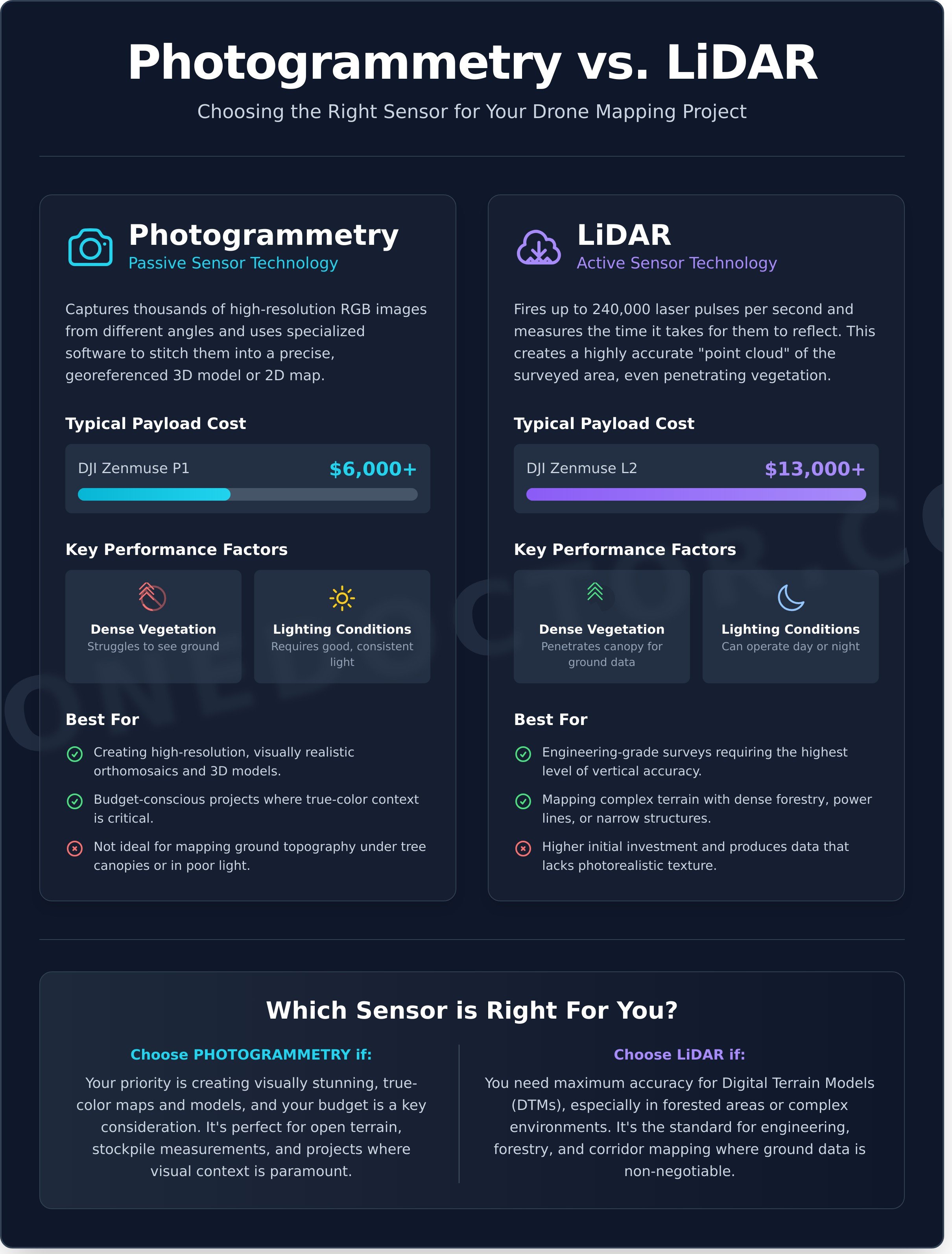
Fotogrametría vs. LiDAR: Eligiendo el sensor correcto
Elegir entre estas dos tecnologías es la decisión más importante que tomarás en el mapeo y levantamiento con drones. No se trata solo de tu presupuesto; se trata de la física de la luz. La fotogrametría es una tecnología de sensor pasivo. Captura imágenes RGB de alta resolución y utiliza software para unirlas en un mapa. LiDAR es un sensor activo. Dispara hasta 240,000 pulsos láser por segundo y mide el tiempo que tardan en regresar. La brecha de costos se está reduciendo, pero sigue siendo significativa. Un sensor RGB de nivel profesional como el DJI Zenmuse P1 cuesta aproximadamente $6,000. En contraste, una carga útil LiDAR de alta gama como el Zenmuse L2 a menudo supera los $13,000. Estás pagando por la capacidad de crear datos donde las cámaras fallan. Este desglose de Fotogrametría vs. LiDAR de expertos de la industria destaca que, si bien la fotogrametría ofrece un detalle visual superior, LiDAR proporciona una precisión estructural inigualable en entornos difíciles.El poder de la fotogrametría
La fotogrametría convierte tu dron en un escáner volador utilizando algoritmos de "Estructura a partir del movimiento" (SfM). Software como Pix4D o DroneDeploy analiza miles de fotos para encontrar píxeles coincidentes. Para obtener un resultado limpio, debes seguir la regla 80/80: 80% de superposición frontal y 80% de superposición lateral. Si bajas de estos números, tus modelos 3D se verán distorsionados o "derretidos". Este método es el campeón para minas a cielo abierto y pilas de acopio. Ofrece ortomosaicos de alta resolución donde cada píxel tiene una coordenada real. Si necesitas mostrar a un cliente exactamente cómo se ve un sitio el 12 de junio a las 10:00 AM, la fotogrametría es tu mejor opción. 📸LiDAR: Penetrando el dosel
LiDAR es el rey indiscutible de la "verdad terrestre". Debido a que utiliza pulsos láser, puede encontrar los pequeños huecos entre las hojas para llegar al suelo de abajo. Esto te permite crear un Modelo Digital del Terreno (MDT) incluso en un bosque denso. Utiliza georreferenciación directa, lo que significa que cada punto en tu nube 3D se posiciona instantáneamente a través de una IMU y GNSS a bordo. No siempre necesitas Puntos de Control en Tierra (GCP) para obtener una precisión de 5 centímetros. A principios de 2026, los analistas de la industria predicen que los costos del hardware LiDAR bajarán otro 20%, haciéndolo accesible incluso para pequeñas empresas topográficas de 3 personas. Es la única opción para inspecciones de líneas eléctricas o misiones nocturnas donde las cámaras son inútiles. Esto lo convierte en el estándar de oro para proyectos de mapeo y levantamiento con drones que involucren bosques densos o infraestructura compleja. 🚨 Si estás listo para actualizar tu flota pero no estás seguro de qué sensor se adapta a tu flujo de trabajo específico, siempre puedes consultar con nuestros técnicos expertos para encontrar la combinación perfecta. No adivines con tu equipo; ¡obtén la potencia profesional que tus proyectos merecen! 🔥- Fotogrametría: Ideal para inspecciones visuales, modelos de malla 3D y proyectos con presupuesto limitado.
- LiDAR: Ideal para levantamientos topográficos bajo la cubierta de árboles, detección de objetos delgados y condiciones de poca luz.
El flujo de trabajo de mapeo profesional: Del vuelo a los entregables
Dominar el flujo de trabajo de mapeo y levantamiento con drones convierte un vuelo estándar en un activo de datos de alta precisión. Comienza antes incluso de que giren los rotores. Necesitas un plan sólido como una roca para asegurarte de que cada píxel cuente. Este proceso de cinco pasos es el estándar de la industria para entregar resultados de calidad profesional en los que los clientes confían. 🚨 ¡No te conformes con datos mediocres; eleva tus capacidades con un enfoque estructurado!
Elementos esenciales de la planificación de la misión
La Distancia de Muestreo en Tierra (GSD) es tu métrica más vital. Si vuelas un DJI Mavic 3 Enterprise a 250 pies, probablemente obtendrás una GSD de 2.1 cm por píxel. Altitudes más bajas significan mejor resolución pero tiempos de vuelo significativamente más largos. Utiliza sensores de seguimiento del terreno para mantener tu dron a una altura constante sobre la superficie, especialmente en sitios con más del 15% de cambios de pendiente. Siempre verifica tus autorizaciones LAANC a través del marco FAA Parte 107 antes del despegue. Omitir una simple verificación del espacio aéreo puede resultar en multas que superan los $30,000. Para aquellos que recién comienzan, revisar una guía completa de mapeo con drones ayuda a aclarar estos requisitos técnicos iniciales.
Logrando una precisión de grado topográfico
La elección entre RTK (Real-Time Kinematic) y PPK (Post-Processed Kinematic) depende completamente de la conectividad de tu sitio. RTK es el estándar de oro para la corrección en tiempo real en 2026. Si estás trabajando en un cañón remoto sin servicio celular, PPK es tu mejor opción. Procesa los datos de ubicación después del vuelo para asegurar la precisión. Sin embargo, no te saltes los GCP. Incluso con un dron habilitado para RTK, colocar de 5 a 8 marcadores físicos por cada 40 acres actúa como una póliza de seguro vital. Estos puntos verifican tus datos contra puntos de referencia topográficos conocidos. ¡Compra con confianza sabiendo que tus datos son a prueba de balas!
- Paso 1: Planificación de la misión. Define tus límites y establece una superposición del 75% frontal y 70% lateral para asegurar que el software tenga suficientes puntos de coincidencia.
- Paso 2: Control terrestre. Coloca Puntos de Control en Tierra (GCP) en un patrón de "5 dados" en todo el sitio para obtener la máxima precisión absoluta.
- Paso 3: Ejecución. Utiliza aplicaciones de vuelo automatizadas como DJI Pilot 2. Monitorea tu enlace de datos en tiempo real para detectar cualquier brecha en la cobertura de inmediato.
- Paso 4: Procesamiento. Sube tus imágenes en bruto a motores como DJI Terra o Pix4D. Estas herramientas transforman 600 JPEGs en una densa nube de puntos y una malla 3D texturizada en unos 45 minutos.
- Paso 5: Análisis. Extrae el valor. Calcula volúmenes de existencias con un 99% de precisión en comparación con los métodos terrestres tradicionales. Genera mapas de pendientes y líneas de contorno con intervalos de 0.1 pies para equipos de ingeniería.
Una vez completado el análisis, el paso final es entregar los activos a tus clientes. Un flujo de trabajo profesional se extiende a la gestión eficiente de contratos, aprobaciones y pagos. Para aquellos que buscan optimizar estas operaciones críticas para el negocio, pueden obtener más información sobre Chaindoc, una plataforma que integra la gestión de documentos y pagos seguros.
La eficiencia es el nombre del juego. El mapeo y levantamiento con drones profesional no se trata solo de tomar fotos; se trata de crear un gemelo digital que refleje la realidad. La mayoría de las empresas de construcción reportan una reducción del 65% en el tiempo de levantamiento al cambiar a este flujo de trabajo automatizado. Es un elemento imprescindible para cualquier obra moderna. ¡Asegura tu equipo hoy y comienza a entregar resultados que superen a la competencia! Nuestro equipo en Drone Doctor está listo para ayudarte a elegir el kit perfecto para estas misiones de alto riesgo.
Los mejores drones de mapeo para 2026: Potencias empresariales
La precisión es la única moneda que importa en 2026. Si todavía estás utilizando hardware de grado de consumidor para el mapeo y la topografía con drones, estás dejando miles de dólares sobre la mesa. El DJI Matrice 350 RTK se erige como el buque insignia indiscutible para operaciones LiDAR de alta resistencia. Admite una carga útil máxima de 2.7 kg y ofrece 55 minutos de tiempo de vuelo. Esta bestia está diseñada para el sensor LiDAR Zenmuse L2, que cuenta con un rango de detección de 450 metros y una precisión vertical de 5 cm. Es la elección profesional para el modelado de terrenos de alta densidad.
- DJI Matrice 350 RTK: El caballo de batalla versátil para misiones multisensor.
- DJI Mavic 3 Enterprise (M3E): El rey portátil de la fotogrametría con obturador mecánico.
- Serie Autel EVO II RTK: Una alternativa segura y de alta resolución para contratos gubernamentales sensibles.
- Construcciones personalizadas: Equipos especializados para sensores multiespectrales o de ultra alta resolución de 100 MP.
El ecosistema DJI: Dominando el mercado de la topografía
El M3E es el dron de mapeo de nivel de entrada más recomendado para el 90% de las nuevas empresas. Su sensor CMOS 4/3 de 20 MP utiliza un obturador mecánico para eliminar la distorsión del obturador rodante. Combínalo con el Zenmuse P1 para una fotogrametría de cuadro completo de élite de 45 megapíxeles. 🚨 ¡Actúa AHORA para asegurar las últimas actualizaciones de firmware de 2026! Estas actualizaciones mejoran los tiempos de convergencia RTK en un 25%. ¡Nuestros expertos como José y Liz se aseguran de que tu equipo esté listo para la misión! ¡Se habla Español! 🔥
Durabilidad empresarial y ROI
Invertir $15,000 en un equipo de drones requiere un camino claro hacia la ganancia. Los datos de enero de 2025 muestran que el 82% de las empresas topográficas logran un ROI completo en 12 meses al reemplazar los equipos terrestres tradicionales. Este hardware está construido para las trincheras. Con una clasificación IP55 en el M350, puedes seguir trabajando bajo lluvia ligera o en sitios de construcción polvorientos. No tienes que empacar cuando cambia el clima.
La continuidad de la misión lo es todo para una operación rentable de mapeo y levantamiento con drones. Las baterías intercambiables y la estación de baterías inteligente BS65 permiten el intercambio en caliente. Esto mantiene tu bloqueo GNSS activo y ahorra 15 minutos de tiempo de recalibración por ciclo de batería. Para proyectos gubernamentales, el Autel EVO II RTK V3 proporciona una resolución de 6K sin las preocupaciones de seguridad de los datos que a menudo se asocian con otros fabricantes. Es un elemento imprescindible para los contratos municipales de 2026. 💳
Las construcciones personalizadas y las integraciones de sensores especializados están experimentando un crecimiento del 15% en el sector para 2026. Estos equipos a menudo incorporan cámaras Phase One o sensores térmicos para inspecciones de servicios públicos que las unidades estándar no pueden manejar. Ya sea que necesites un M3E estándar o un hexacóptero personalizado de gran elevación, el hardware adecuado determina tus límites de precisión. No te conformes con menos de una precisión a nivel centimétrico cuando tu reputación está en juego.
¿Listo para actualizar tu flota? Compra en nuestro inventario de drones empresariales y obtén el apoyo experto del líder en ventas, reparación y servicio.
Protegiendo tu inversión: Mantenimiento, piezas y reparación experta
Invertir $15,000 o más en una plataforma de alta gama para el mapeo y la topografía con drones es solo el comienzo de tu viaje. La filosofía de "Drone Doctor" se centra en una verdad innegable: el mantenimiento preventivo siempre es más barato que un accidente catastrófico. Las estadísticas de 2023 muestran que las inspecciones regulares de 50 horas reducen el riesgo de fallas mecánicas en el aire en un 65%. Una simple revisión de servicio de $250 puede prevenir una factura de reparación de $5,000 o la pérdida total de tu fuselaje. Lo vemos a diario; un piloto se salta una inspección de motor de rutina, y luego un rodamiento se agarra a 300 pies. El cuidado preventivo mantiene tu flota en el aire y tus datos precisos.
Los fallos comunes en el campo a menudo implican la calibración del cardán y el desgaste del motor. El cardán es el componente mecánico más activo de su aeronave; realiza cientos de microajustes por segundo para mantener su sensor nivelado. Con el tiempo, los cables planos y los motores dentro del conjunto del cardán se degradan. Si los datos de cartografía y topografía con drones comienzan a mostrar efectos de "gelatina" o inclinación del horizonte, es probable que su calibración esté fallando. Además, los motores están clasificados para horas de vuelo específicas. Si siente alguna resistencia o escucha un sonido de chirrido al girar las hélices con la mano, es hora de un reemplazo inmediato. Nuestra tienda ha realizado más de 1,200 cambios de motor desde enero de 2022, asegurando que los pilotos permanezcan en el aire sin incidentes.
Almacenar piezas esenciales es una estrategia no negociable para cualquier operación empresarial seria. No debe esperar a una avería para pedir reemplazos. Mantenga estos artículos en su estuche de vuelo en todo momento:
- Hélices: Reemplácelas cada 30 horas de vuelo o al primer signo de una fisura capilar.
- Tren de aterrizaje: Estos componentes absorben el estrés de cada aterrizaje; una grieta capilar aquí puede provocar el colapso del bastidor durante un aterrizaje forzoso.
- Cubiertas del sensor y lápices para lentes: El polvo es el enemigo de un sensor LiDAR de $10,000. Limpie su vidrio después de cada tres vuelos para mantener la claridad de los datos.
El líder en ventas, reparación y servicio
Drone Doctor apoya todo el ciclo de vida empresarial mucho después de que usted haga clic en "comprar". Entendemos que cada hora que su dron está en el taller es una hora que no está facturando a sus clientes. Por eso ofrecemos un tiempo de respuesta de diagnóstico de 48 horas para todos los equipos de nivel empresarial. Nuestros técnicos, incluidos expertos como José, utilizan software de fábrica para realizar análisis de sistemas profundos a los que las aplicaciones de consumo no pueden acceder. No solo reparamos el hardware; brindamos servicios expertos de calibración para sensores de mapeo de precisión para garantizar que sus resultados cumplan con los estrictos estándares de precisión ASPRS de 2024. También ofrecemos soporte bilingüe en español para garantizar que todos los miembros de nuestra comunidad reciban la ayuda experta que merecen.
Actúe AHORA: Asegure su plan de soporte empresarial
No espere a que aparezca un mensaje de "Error del sistema" mientras está en un sitio de trabajo a 200 millas de casa. Asegure su plan de soporte empresarial hoy mismo para obtener acceso prioritario a nuestra cola de reparaciones y piezas con descuento. Las reparaciones de bricolaje en drones de mapeo sofisticados a menudo anulan la garantía del fabricante y pueden arruinar las certificaciones de precisión interna del GPS y la IMU. De hecho, el 40% de los drones que recibimos para reparaciones de emergencia son el resultado de intentos fallidos de reparación en casa. Compre con confianza sabiendo que nuestro equipo, incluida Liz, está aquí para ayudarle a tener éxito. ¡Su satisfacción es nuestra máxima prioridad! 🚨🛍️💳🔥
Domine los cielos con tecnología de precisión 2026
El panorama de la cartografía y topografía con drones ha cambiado hacia una eficiencia sin precedentes. Para 2026, la brecha entre la fotogrametría y el LiDAR se ha reducido significativamente. Sensores como el Zenmuse L2 ahora permiten a los equipos capturar una precisión subcentimétrica en sitios de 500 acres en un solo vuelo. Elegir el hardware empresarial adecuado es solo la mitad de la batalla. También debe implementar un riguroso programa de mantenimiento de 50 horas para proteger sus activos de tiempos de inactividad prevenibles. El éxito en el campo requiere una mezcla de sensores de vanguardia y una red de soporte confiable que comprenda lo que está en juego en la recopilación de datos profesional. 🚨
Drone Doctor es el líder indiscutible en ventas, reparación y servicio. Como distribuidor oficial de DJI Enterprise, proporcionamos más que solo equipos. Nuestro personal experto, incluidos especialistas como Liz y José, ofrecen el soporte técnico práctico que mantiene sus operaciones funcionando 24/7. Ya sea que esté actualizando su flota o necesite una reparación experta, estamos aquí para ayudarle a tener éxito. Es hora de equipar a su equipo con las mejores herramientas de la industria. Compre con confianza porque su satisfacción es nuestra máxima prioridad. 🔥
¡Compre los últimos drones de mapeo empresarial en Drone Doctor!
Preguntas frecuentes
¿Cuál es el dron más preciso para topografía en 2026?
El DJI Matrice 350 RTK equipado con el sensor Zenmuse P1 es el dron más preciso para cartografía y topografía con drones en 2026. Esta combinación ofrece una precisión horizontal de 3 centímetros y una precisión vertical de 5 centímetros sin necesidad de puntos de control en tierra. Es el estándar de oro para los profesionales que exigen "Potencia profesional" y precisión en cada sitio de trabajo.
¿Cuánto cuesta una configuración profesional de mapeo con drones?
Una configuración completa de mapeo con drones profesional suele costar entre $15,000 y $45,000 en 2026. Este rango de precios incluye un fuselaje de alta gama, un sensor de cuadro completo de 45 megapíxeles y una suscripción de software de 12 meses para el procesamiento de datos. También debe presupuestar $2,500 adicionales para baterías de alta capacidad y una caja de transporte resistente para proteger su inversión. ¡Compre con confianza porque somos el líder en ventas y servicio!
¿Necesito una licencia especial para el mapeo y la topografía con drones?
Debe poseer un Certificado de Piloto Remoto FAA Parte 107 válido para realizar cualquier mapeo y topografía comercial con drones en los Estados Unidos. Esta licencia le exige aprobar un examen de conocimientos de 60 preguntas y completar un curso de capacitación recurrente cada 24 meses. Operar con fines de lucro sin esta certificación puede resultar en sanciones civiles que superan los $32,000 por infracción. Actúe AHORA y obtenga la certificación para comenzar su carrera profesional legalmente.
¿Puedo usar un DJI Mini para mapeo profesional?
No debe usar un DJI Mini para mapeo profesional de alta precisión porque carece de un obturador mecánico y hardware RTK. Si bien es una excelente herramienta de nivel de entrada, su obturador electrónico crea un 15 por ciento más de distorsión de imagen que una cámara de obturador global. Para obtener resultados que cumplan con los estándares de ingeniería, necesitará el Mavic 3 Enterprise, que está construido específicamente para "Elevar Capacidades" en el campo.
¿Cuál es la diferencia entre RTK y PPK en la topografía con drones?
RTK (Real-Time Kinematic) corrige su ubicación GPS en tiempo real durante el vuelo, mientras que PPK (Post-Processed Kinematic) corrige los datos después de que el dron aterriza. PPK suele ser más confiable en entornos con un 40 por ciento o más de obstrucción de la señal porque no requiere un enlace de radio constante entre el dron y la estación base. Ambos métodos proporcionan una precisión a nivel de centímetro, pero PPK ofrece más flexibilidad en terrenos remotos o accidentados.
¿Cuánto tiempo se tarda en procesar los datos de mapeo con drones?
El procesamiento de un conjunto de datos de 500 imágenes de alta resolución suele tardar entre 2 y 6 horas en una estación de trabajo moderna. Si utiliza una computadora con 64 GB de RAM y una GPU dedicada de 12 GB, verá un tiempo de respuesta un 30 por ciento más rápido que con el hardware de oficina estándar. Las plataformas basadas en la nube a menudo pueden procesar estos mismos archivos en menos de 90 minutos si tiene una conexión a Internet de fibra de alta velocidad.
¿Con qué frecuencia se debe realizar el mantenimiento de un dron de mapeo empresarial?
Debe realizar el mantenimiento de su dron de mapeo empresarial cada 200 horas de vuelo o cada 6 meses para garantizar el máximo rendimiento. El mantenimiento regular en Drone Doctor mantiene sus gimbals y motores calibrados al 100 por ciento de eficiencia. Verificamos microfisuras y actualizamos su firmware para evitar el 95 por ciento de las fallas comunes en vuelo. ¡Confíe en el líder en reparación y servicio para mantener su flota operativa!
¿Es LiDAR mejor que la fotogrametría para obras de construcción?
LiDAR es superior para obras de construcción con un 20 por ciento o más de vegetación densa porque los pulsos láser pueden penetrar las hojas para llegar al suelo. Sin embargo, la fotogrametría es un 50 por ciento más rentable para cálculos simples de volumen de existencias y proporciona mejores texturas visuales en 3D para las partes interesadas del proyecto. Elija LiDAR si necesita una precisión de 2 centímetros en terrenos complejos, pero opte por la fotogrametría para el seguimiento del progreso estándar del sitio.