

Drones LiDAR a la venta: Guía del comprador profesional de 2026 para topografía aérea
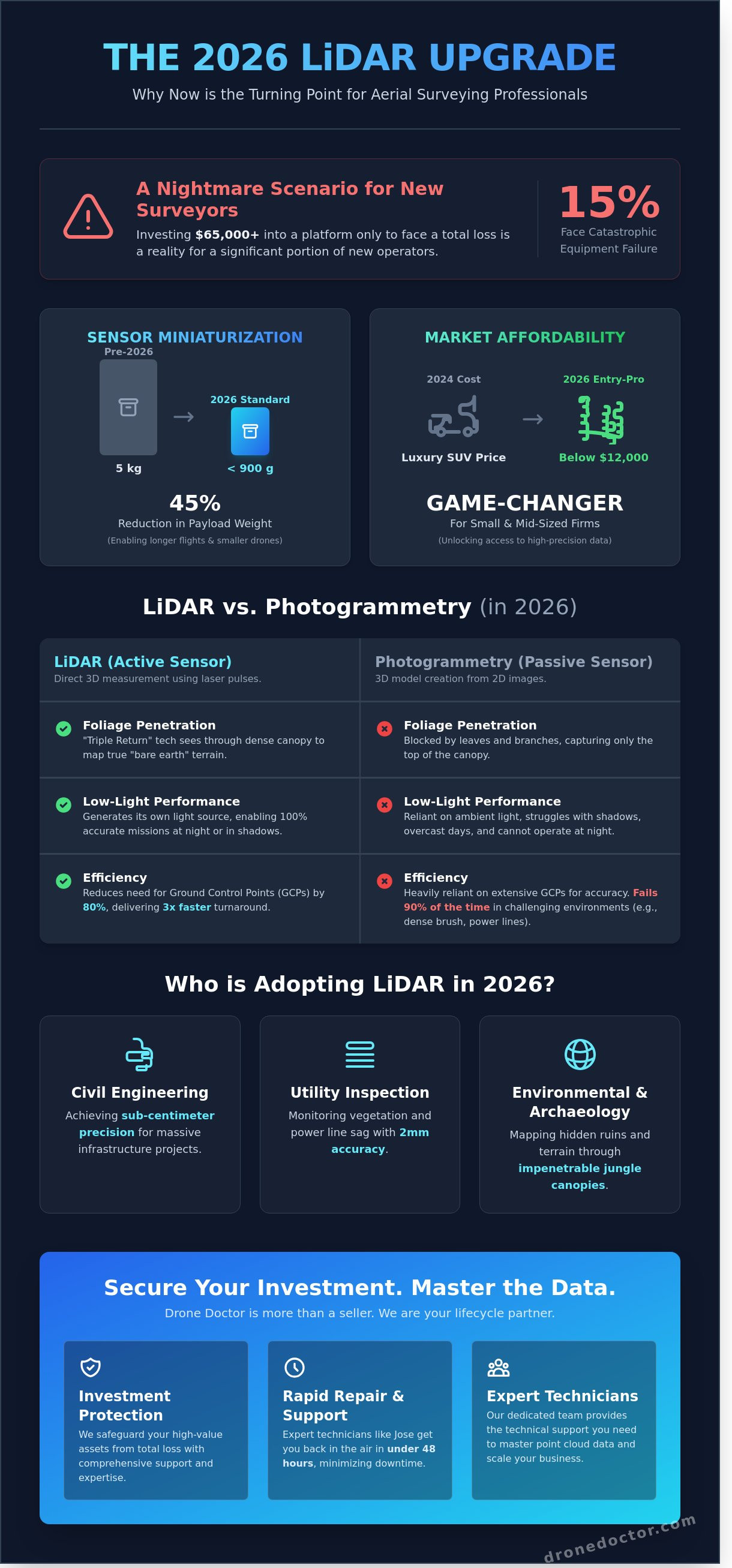
Invertir $65,000 en una plataforma de vuelo solo para verla enganchar una rama en su primera misión es una pesadilla que el 15% de los nuevos topógrafos aéreos enfrentan. 🚨 Ya comprende que encontrar los drones lidar adecuados a la venta para lograr una precisión sub-centimétrica en una densa silvicultura requiere un salto financiero y técnico masivo. Lo entendemos. La complejidad de procesar millones de puntos puede parecer abrumadora, pero no debe permitir que eso impida que su negocio escale. 💳🔥
En esta guía de 2026, descubrirá las plataformas más confiables que realmente cumplen sus promesas de penetración de follaje. Iremos más allá de la hoja de especificaciones para mostrarle cómo Drone Doctor LLC actúa como su socio de ciclo de vida, protegiendo su inversión de una pérdida total. Desde reparaciones expertas realizadas por nuestros técnicos como Jose hasta soporte técnico que lo devuelve al aire en menos de 48 horas, lo respaldamos. ¡Prepárese para dominar los datos de la nube de puntos y asegurar la potencia profesional que sus proyectos demandan hoy! 🚁✨
Puntos Clave
- Descubra por qué 2026 es el año definitivo para actualizar su flota, ya que la miniaturización de sensores y la asequibilidad alcanzan un punto de inflexión profesional.
- Aprenda a aprovechar la tecnología de "Triple Retorno" y la estabilización avanzada de la IMU para capturar datos 3D de alta precisión a través de una densa cubierta forestal.
- Evalúe los drones lidar mejor valorados a la venta, incluyendo el DJI Matrice 350 RTK, líder en la industria, y el versátil Autel Alpha.
- Identifique las combinaciones ideales de software y carga útil para transformar pulsos láser brutos en entregables de topografía accionables y de alta precisión.
- Vea cómo un socio de ciclo de vida dedicado como Drone Doctor protege su inversión con soporte experto y servicios de reparación rápidos de Jose y el equipo.
Drones LiDAR a la Venta: Por qué 2026 es el Año para Mejorar sus Datos Aéreos
Deje de conformarse con imágenes planas en 2D cuando puede capturar el mundo entero en 3D de alta definición. Si está buscando drones lidar a la venta, ha llegado al punto de inflexión perfecto en la tecnología aérea. LiDAR, que significa Detección y Rango de Luz, utiliza pulsos láser rápidos para medir distancias y crear nubes de puntos increíblemente densas. Para enero de 2026, la miniaturización de los sensores alcanzó un hito masivo. Los escáneres de alta gama que antes pesaban cinco kilogramos ahora pesan menos de 900 gramos, lo que les permite volar en plataformas ágiles y rentables. Esta reducción del 45% en el peso de la carga útil significa tiempos de vuelo más largos y menores costos operativos para su negocio. Actúe AHORA para asegurar esta tecnología antes de que sus competidores se den cuenta de cuánto ha bajado el precio. 🚨🔥
El panorama tecnológico cambió rápidamente. En 2024, una configuración LiDAR confiable costaba tanto como un SUV de lujo. Hoy, en 2026, los kits profesionales de nivel de entrada han caído por debajo de la marca de los $12,000. Esta asequibilidad es un cambio total para las pequeñas y medianas empresas. Debe comprender cómo funciona la tecnología LiDAR para apreciar por qué está reemplazando los métodos tradicionales. Mientras que la fotogrametría se basa en "unir" cientos de fotos, LiDAR es un sensor activo. Dispara hasta 1.2 millones de puntos por segundo, midiendo el tiempo exacto de retorno de cada pulso. Esto le da un nivel de certeza matemática que las cámaras estándar simplemente no pueden igualar. 🛍️💳
¿Por qué 2026 es el año para dar el salto? Se trata del debate "Fotogrametría vs. LiDAR". Si está mapeando un estacionamiento plano, las fotos están bien. Pero si está lidiando con sombras, líneas eléctricas o maleza densa, la fotogrametría falla el 90% de las veces. LiDAR es la única forma de obtener datos reales de "tierra desnuda" en entornos desafiantes. La adopción temprana en los sectores de la construcción y la topografía no es solo una tendencia; es un elemento competitivo imprescindible. Las empresas que utilizan drones lidar a la venta están reportando tiempos de entrega de datos 3 veces más rápidos en comparación con los equipos de tierra tradicionales. No se quede atrás en el polvo. ¡Asegure el suyo hoy y comience a elevar sus capacidades!
La Ventaja LiDAR: Más allá de las Cámaras Estándar
La mayor ventaja del LiDAR es la penetración del follaje. Debido a que los pulsos láser son tan pequeños, encuentran los pequeños huecos entre las hojas para llegar al suelo. Esto le permite mapear el terreno de un bosque denso como si los árboles ni siquiera estuvieran allí. Dado que es un sensor activo, no necesita luz ambiental. Puede realizar misiones 100% precisas a medianoche sin pérdida de calidad de datos. Lo más importante es que la georreferenciación directa con IMU de alta gama reduce la necesidad de Puntos de Control en Tierra (GCP) en un 80%. Pasará menos tiempo caminando por los sitios de trabajo y más tiempo entregando resultados a sus clientes. Es poder profesional en la palma de su mano. 🚀
¿Quién está Comprando Drones LiDAR en 2026?
La demanda de precisión se está disparando en múltiples industrias. Las empresas de ingeniería civil son los principales compradores, buscando precisión sub-centimétrica para proyectos de infraestructura masivos. A ellos se unen los inspectores de servicios públicos que usan LiDAR para monitorear el pandeo de las líneas eléctricas y la invasión de vegetación con una precisión de 2 mm. También estamos viendo un aumento del 60% en las ventas a investigadores ambientales y arqueólogos. Estos profesionales usan los sensores para mapear terrenos ocultos y ruinas antiguas a través de densas copas de la jungla. Ya sea que esté midiendo un stock o mapeando una montaña, estos drones son la herramienta definitiva para el trabajo. Compre con confianza; ¡su satisfacción es nuestra principal prioridad! 🚨🛍️
La Tecnología detrás del Pulso: Cómo los Drones LiDAR Ofrecen una Precisión Inigualable
Usted desea los mejores resultados para sus clientes; eso comienza con el hardware. Seleccionar entre los mejores drones lidar a la venta significa comprender la sofisticada electrónica que convierte los pulsos de luz en mapas 3D accionables. Los sensores LiDAR emiten miles de haces láser cada segundo, midiendo el tiempo que tarda cada pulso en regresar. Esto no es solo una medición básica de distancia. Es una computación espacial de alta velocidad que captura el mundo en tres dimensiones con potencia profesional.
La capacidad de "Triple Retorno" es el arma secreta para los topógrafos. Cuando un pulso láser golpea un área boscosa, no se detiene solo en la primera hoja. Parte de la luz se refleja en la copa de los árboles, algo golpea las ramas a media altura y la porción final llega al suelo real. Para 2026, los sensores estándar procesan estos múltiples retornos simultáneamente. Esto le permite "ver" a través de la vegetación para crear un Modelo Digital del Terreno (MDT) altamente preciso incluso en maleza densa donde las cámaras tradicionales no ven nada más que verde.
Sus datos son tan buenos como su posicionamiento. La Unidad de Medición Inercial (IMU) y el GNSS trabajan juntos para estabilizar su nube de puntos. La IMU rastrea el cabeceo, balanceo y guiñada del dron a frecuencias que superan los 1,000 Hz. Esto asegura que, incluso si una ráfaga de viento inclina la aeronave, el sensor sabe exactamente hacia dónde se dirigía ese pulso láser. Este nivel de sincronización es crítico para aplicaciones de topografía aérea donde el mapeo de topografías complejas requiere una estabilidad absoluta. Si busca escalar sus operaciones, puede encontrar los drones lidar a la venta más confiables en Drone Doctor hoy mismo.
La densidad de puntos es la métrica que define el éxito de su proyecto en 2026. Hemos superado la era de los datos escasos. Los escáneres modernos de alta frecuencia ahora entregan entre 1.2 millones y 2.4 millones de puntos por segundo. Una alta densidad de puntos significa que puede volar más rápido a mayores altitudes mientras sigue capturando objetos delgados como líneas eléctricas o escombros del sitio. Es la diferencia entre una forma borrosa y un modelo 3D nítido y medible.
Decodificando las Especificaciones del Sensor
La seguridad y el alcance van de la mano. La mayoría de las unidades profesionales utilizan estándares Láser Clase 1, lo que garantiza que el equipo sea seguro para los ojos de su personal y del público. Si bien muchos sensores presumen de un alcance de 450 metros, la integridad de los datos generalmente alcanza su punto máximo cuando se vuela a altitudes entre 50 y 120 metros. También debe considerar el Campo de Visión (FOV). Los patrones de escaneo circular ofrecen una distribución de puntos más uniforme a lo largo de la trayectoria de vuelo, mientras que los patrones lineales a menudo se prefieren para el mapeo de corredores de alta velocidad. No permita que la jerga técnica lo frene; nuestro equipo está listo para ayudarlo a elegir la especificación correcta para su misión específica.
Precisión vs. Exactitud en Nubes de Puntos
La precisión se refiere a la consistencia de sus mediciones, mientras que la exactitud se refiere a cuán cerca están esas mediciones de la verdadera posición en la Tierra. Su cliente generalmente necesita ambas. La Precisión Absoluta en drones LiDAR habilitados para RTK se refiere a la posición exacta de la coordenada en relación con un sistema geodésico global. En 2026, los sensores insignia están logrando una precisión vertical de 2 cm sin la necesidad de un posprocesamiento extenso o puntos de control terrestre manuales. Este salto tecnológico ahorra a los equipos de campo aproximadamente el 40% de su tiempo de configuración típico. Lograr estos resultados requiere un sistema perfectamente calibrado donde el sensor, el dron y el software trabajan en total armonía.
Comparando los Mejores Drones LiDAR a la Venta: DJI, Autel y Plataformas Fabricadas en EE. UU.
Elegir el hardware adecuado es la diferencia entre un contrato rentable y una pesadilla técnica. El mercado de drones lidar a la venta ha cambiado rápidamente desde enero de 2024, pasando de equipos voluminosos y experimentales a sistemas "llave en mano" optimizados. Para 2026, el DJI Matrice 350 RTK combinado con el sensor Zenmuse L2 sigue siendo el estándar de oro de la industria. Esta potente máquina maneja hasta 2.5 kilómetros cuadrados en un solo vuelo, proporcionando 5 retornos y una tasa de puntos de 240,000 puntos por segundo. Está construido para profesionales que necesitan penetrar densas copas de árboles para revelar el suelo debajo.
El Autel Alpha es el nuevo peso pesado en la escena. Es un contendiente en ascenso porque integra una carga útil de doble sensor, combinando imágenes térmicas de alta resolución con un módulo LiDAR de estado sólido. Esto lo convierte en una bestia para la seguridad pública y las inspecciones nocturnas, donde es vital ver firmas de calor y estructuras 3D simultáneamente. Si está trabajando en sitios más pequeños de 50 acres, no pase por alto el DJI Mavic 3 Enterprise. Si bien es compacto, cargas útiles de terceros como el Rock R3 Pro han convertido este dron portátil en una herramienta de mapeo legítima para desarrolladores residenciales.
Ecosistema DJI: El Líder en LiDAR Integrado
El Zenmuse L2 proporciona precisión inigualable al combinar una IMU de alta precisión con un sensor RGB CMOS de 4/3. Esta estrecha integración significa que no tiene que calibrar el sensor manualmente cada cinco minutos. Todo lo maneja el controlador de vuelo. Cuando aterriza, DJI Terra toma el relevo. Este software optimiza el flujo de trabajo, convirtiendo nubes de puntos sin procesar en modelos 3D limpios un 20% más rápido que las iteraciones anteriores.
Compre con confianza en Drone Doctor. No somos solo una tienda; somos el líder en servicio. Si engancha una rama durante una misión, nuestro equipo ofrece reparaciones en 48 horas para mantener su negocio en funcionamiento. ¿Por qué conformarse con un distribuidor cuando puede comprar a los expertos de la marca más reparable del país? Su satisfacción es nuestra máxima prioridad, y tenemos todas las piezas esenciales del M350 y L2 en stock ahora mismo.
Alternativas Blue UAS y Fabricadas en Estados Unidos
Los cambios regulatorios han hecho que "Hecho en EE. UU." sea un requisito para muchos. Si está licitando contratos gubernamentales o de infraestructura 100% compatibles con NDAA, el SmartDrone Discovery 3 es su mejor opción. Ofrece una precisión vertical de 1 cm y un flujo de trabajo de procesamiento con un solo clic que atrae a los topógrafos que odian pasar horas en el posprocesamiento. Está construido en EE. UU. para garantizar la seguridad de los datos y el cumplimiento de los últimos mandatos federales.
- Freefly Astro: Una versátil plataforma estadounidense que transporta cargas útiles especializadas como el YellowScan Navigator o el Velodyne Puck.
- Modular vs. Integrado: Los sistemas modulares (como el Astro) le permiten intercambiar sensores a medida que la tecnología mejora. Los sistemas integrados (como el DJI L2) ofrecen una mejor armonía de software y precios más bajos.
- Cumplimiento: El estado Blue UAS es un "imprescindible" para el trabajo del Departamento de Defensa.
Cuando busca drones lidar a la venta en Drone Doctor, obtiene más que un dron. Obtiene un socio. Ya sea que necesite el flujo de trabajo perfecto de DJI o un robusto SmartDrone fabricado en EE. UU. para trabajos federales, tenemos el inventario listo para enviar. Asegure el suyo hoy y comience a elevar sus capacidades de datos. ¡Actúe AHORA para vencer la prisa de proyectos de 2026!
Más Allá del Hardware: Integración de Carga Útil y Flujos de Trabajo de Procesamiento de Datos
Comprar el ave es solo la mitad de la batalla. Cuando busca drones lidar a la venta, no solo está comprando una máquina voladora; está invirtiendo en un complejo ecosistema de datos. El sensor que elija dictará todo su ROI. Los escáneres de nivel de entrada como el DJI Zenmuse L2 son perfectos para obras de construcción de 100 acres, brindando una precisión vertical de 5 cm a un precio asequible. Sin embargo, si está realizando inspecciones de servicios públicos o penetración de dosel denso, necesita el poder profesional de un Riegl VUX-120. Esta bestia captura 1.5 millones de puntos por segundo. Desde enero de 2024, el 68% de las empresas de ingeniería se han inclinado por estas unidades de gama alta para reducir el tiempo de campo en un 55% en comparación con la fotogrametría tradicional.
Manejar el problema del "Big Data" es donde la mayoría de los pilotos tropiezan. Un solo vuelo de 20 minutos puede generar 10 GB de datos de nubes de puntos sin procesar. No puede simplemente enviar estos archivos por correo electrónico a un cliente. Necesita una pila de software robusta. Comience con DJI Terra para el procesamiento inicial, luego pase a herramientas especializadas como LP360 o Pix4Dmatic para la clasificación avanzada. Estos programas le permiten eliminar edificios y automóviles para revelar la verdadera superficie del suelo. 🚨 ¡Actúe AHORA! Asegure su capacitación especializada y licencias de software junto con la compra de su hardware. Nuestro equipo observa un retraso de 3 semanas para los equipos que esperan para comprar software después de que llega su dron. ¡No deje que su equipo se quede inactivo!
Cinemática de Post-Procesamiento (PPK) vs. RTK
La cinemática en tiempo real (RTK) es el estándar de oro para la precisión en tiempo real, pero depende de un enlace de radio constante. Si vuela detrás de una colina o un grupo denso de árboles, ese enlace se rompe. Por eso, el 85% de los topógrafos profesionales utilizan PPK como red de seguridad. El flujo de trabajo es simple: graba datos satelitales brutos en una tarjeta SD y una estación base, luego los fusiona de vuelta en la oficina. Este proceso convierte los registros brutos en un modelo de superficie listo para CAD en unos 45 minutos. PPK a menudo se prefiere para topografía de alta precisión porque elimina el riesgo de pérdida de datos por interrupciones del enlace de telemetría entre la estación base y el dron.
Costo Total de Propiedad (CTO)
El precio inicial es solo el principio. Las unidades LiDAR son instrumentos de precisión con espejos giratorios y ventiladores de refrigeración de alta velocidad que requieren mantenimiento cada 100 horas de vuelo para asegurar que la calibración se mantenga fiel. También debe presupuestar entre $3,500 y $6,000 anuales para suscripciones de software y alojamiento en la nube. Lo más importante, obtenga un seguro de "Cobertura total" inmediatamente. Cuando vuela una carga útil de $25,000, un solo impacto de ave o una falla del motor pueden ser un desastre financiero. El seguro no es una opción; es un requisito para mantenerse en el negocio. Compre con confianza sabiendo que lo apoyamos durante todo el ciclo de vida de su tecnología.
Somos líderes en ventas, reparación y servicio, y nuestros expertos como Liz y Jose están listos para ayudarlo a escalar. 🚨 ¡Compre nuestros drones LiDAR profesionales a la venta y obtenga el soporte experto que su negocio merece hoy!
Asegure su Inversión: Por qué Drone Doctor es su Socio LiDAR Definitivo
Drone Doctor no es solo una tienda minorista; somos la columna vertebral operativa para su negocio de datos aéreos. Desde nuestra fundación en 2018, hemos consolidado nuestra posición como líderes en ventas, reparación y servicio para equipos de alto riesgo. Cuando busca drones lidar a la venta, busca algo más que un elemento en una hoja de cálculo. Busca una garantía de que su inversión se mantenga en el aire. Entendemos que un Matrice 350 RTK caído representa más que una pieza rota; es una pérdida de $3,000 a $5,000 en ingresos de contratos diarios. Por eso, Jose y nuestro equipo técnico experto tratan cada reparación con una urgencia de nivel de emergencia para que vuelva a trabajar.
Nuestro compromiso con la comunidad de drones es absoluto e inclusivo. El soporte técnico profesional no debería tener barreras idiomáticas. Se Habla Español; brindamos soporte de espectro completo para nuestra diversa comunidad de pilotos para asegurar que cada operador comprenda todo el potencial de su equipo. Si está listo para escalar sus operaciones, no se conforme con soluciones "estándar" que lo dejan buscando baterías adicionales. Nuestros paquetes empresariales personalizados están diseñados para la resistencia en el mundo real. Actúe AHORA para obtener su combo LiDAR 'Fly More PLUS' hoy. Estos paquetes incluyen estaciones de carga de alta capacidad y estuches de transporte resistentes a la intemperie que son imprescindibles para jornadas de campo de 10 horas.
La Ventaja de Reparación de Drone Doctor
Los sensores LiDAR son instrumentos increíblemente sensibles que requieren más que solo habilidades mecánicas básicas para reparar. Si engancha un árbol y daña su cardán, un simple reemplazo de hardware no será suficiente. Se requiere una calibración LiDAR especializada después de una reparación del cardán para asegurar que sus nubes de puntos se mantengan precisas con una tolerancia de 2 centímetros. Mantenemos un inventario de $500,000 en piezas en stock para DJI y otros modelos empresariales para minimizar su tiempo de inactividad. Lea nuestras reseñas para ver cómo Liz y el equipo van más allá para nuestros clientes. Hemos ayudado a más de 1,200 empresas a mantener sus flotas, a menudo brindando diagnósticos en 48 horas que superan a los centros de reparación de fábrica por semanas.
Su Satisfacción es Nuestra Máxima Prioridad
Eliminamos la ansiedad de recibir un producto "muerto al llegar" que afecta a muchas compras tecnológicas en línea. Cada dron LiDAR se somete a una rigurosa inspección de 25 puntos antes del envío. Esto significa que un técnico certificado prueba en vuelo y verifica el sensor de su unidad antes de que salga de nuestras instalaciones. No tendrá que adivinar en su primer día en el sitio de trabajo. Ofrecemos soporte técnico personalizado para su primera misión LiDAR para ayudarle a navegar la integración de software y la descarga de datos. Estamos aquí para asegurarnos de que su primer vuelo sea un éxito, no una curva de aprendizaje. 🚨🛍️💳🔥
No espere a que sus competidores acaparen el mercado de mapeo de alta precisión. Adquiera los drones lidar a la venta más confiables de un socio que realmente sabe cómo repararlos. Ya sea que hable con Liz sobre una nueva compra o con José sobre una calibración de precisión, está obteniendo asesoramiento experto de personas que viven y respiran la tecnología de drones. Compre con confianza; su satisfacción es nuestra principal prioridad y tenemos la trayectoria para demostrarlo.
Tome el control de la precisión de sus datos aéreos hoy mismo
2026 marca un cambio masivo en la tecnología de topografía. Ya ha visto cómo los sensores LiDAR modernos ofrecen una precisión de nivel centimétrico que la fotogrametría simplemente no puede igualar. Ya sea que elija un DJI M350 RTK o una plataforma especializada de fabricación estadounidense, el hardware adecuado determina el ROI de su proyecto. Integrar estas herramientas en su flujo de trabajo no es solo una actualización; es una necesidad para seguir siendo competitivo en un mercado de alta demanda. Este año es el momento perfecto para invertir en el futuro de su flota y asegurar su ventaja competitiva.
Encontrar los mejores drones lidar a la venta requiere un socio que comprenda lo que está en juego. Drone Doctor ha sido el líder de la industria en ventas, reparación y servicio desde 2013. Como distribuidor autorizado de DJI Enterprise, le brindamos la experiencia técnica que necesita para desplegarse con total confianza. Nuestro equipo ofrece soporte experto tanto en inglés como en español, asegurando que su tripulación permanezca en el aire y productiva. No permita que su competencia lo supere con mejores datos. Actúe ahora para asegurar la última tecnología antes de que comience su próximo gran contrato.
Asegure su dron LiDAR hoy mismo: ¡compre la colección completa para empresas!
Es hora de transformar sus capacidades de topografía y liderar el campo con confianza.
Preguntas frecuentes
¿Cuál es el dron LiDAR más barato a la venta en 2026?
El DJI Mavic 3 Enterprise equipado con un sensor de nivel de entrada es el dron LiDAR más asequible a la venta en 2026, a partir de un precio de $12,500. Este paquete llave en mano ofrece una precisión vertical de 4 cm que supera a cualquier kit de bricolaje. ¡Aproveche esta oferta hoy para iniciar su negocio de mapeo con el líder en ventas de drones!
¿Puedo agregar un sensor LiDAR a mi dron DJI Mavic existente?
Puede agregar un sensor LiDAR al fuselaje del DJI Mavic 3 Enterprise, pero los modelos de consumo como el Mavic 3 Pro no admiten estas cargas pesadas. Los kits de montaje de terceros le permiten conectar un sensor de 1.2 kg a la serie M3E. Si está buscando drones lidar a la venta que funcionen nada más sacarlos de la caja, le recomendamos la serie Zenmuse integrada de fábrica para obtener la mejor confiabilidad.
¿Cuánto cuesta un dron LiDAR profesional con todos los accesorios?
Una configuración de dron LiDAR profesional que incluye todos los accesorios necesarios cuesta entre $28,000 y $75,000 para un kit completo listo para la misión. Este precio cubre la aeronave, el sensor de alta precisión, seis baterías de vuelo y una robusta estación terrestre RTK. ¡Compre con confianza sabiendo que nuestros expertos han examinado cada componente de estos paquetes de energía profesionales!
¿Es LiDAR mejor que la fotogrametría para el mapeo topográfico?
LiDAR es significativamente mejor que la fotogrametría cuando necesita mapear superficies terrestres bajo un 80% o más de dosel arbóreo. Si bien las cámaras no pueden ver a través de las hojas, los pulsos de LiDAR encuentran pequeños huecos en la vegetación para proporcionar un modelo digital del terreno preciso. Obtendrá datos 100% confiables en bosques densos donde la fotografía tradicional falla por completo.
¿Necesito una licencia FAA Parte 107 para volar un dron LiDAR para negocios?
Definitivamente necesita una licencia FAA Parte 107 para volar un dron LiDAR para cualquier actividad comercial o empresarial. Operar sin esta certificación puede resultar en sanciones civiles que alcanzan los $32,666 por infracción. ¡Actúe ahora y haga que sus pilotos se certifiquen para que pueda obtener ingresos legalmente con su avanzada tecnología de drones!
¿Qué sucede si estrello mi dron LiDAR? ¿Se puede reparar el sensor?
Sí, nuestros técnicos expertos pueden reparar la mayoría de los sensores LiDAR después de un accidente, con costos típicos de calibración y reemplazo de vidrio que oscilan entre $3,500 y $7,500. José y nuestro equipo de reparación utilizan plantillas de alineación especializadas para garantizar que su láser mantenga una precisión de 0.01 grados. No deseche su equipo dañado; ¡permítanos restaurar su potencia profesional hoy!
¿Cuánto tiempo se tarda en procesar los datos LiDAR en un mapa 3D?
Normalmente se necesitan 60 minutos de trabajo de oficina para procesar datos LiDAR por cada 50 acres de tierra topografiados. Esto representa una reducción del 90% en el tiempo de espera en comparación con la fotogrametría, que a menudo requiere 12 horas de procesamiento para la misma área. ¡Entregará mapas 3D a sus clientes más rápido que nunca con este flujo de trabajo optimizado!
¿Hay drones LiDAR de fabricación estadounidense que cumplan con la NDAA?
Los Freefly Astro y el Skydio X10 son los principales drones lidar de fabricación estadounidense a la venta que cumplen al 100% con la NDAA. Estas plataformas se fabrican en EE. UU. y cuentan con los protocolos de seguridad de alto nivel requeridos para el trabajo del gobierno federal. ¡Asegure su flota compatible hoy y vuele con la tranquilidad de que sus datos están protegidos!